Approximately 5 hours ago I published an article speculating about a “Tropical Wave” hovering about in the Atlantic Ocean. At the time, this “Tropical Wave” had a 70% chance of developing into a “Tropical Cyclone” – well now, just a few hours later she has already blossomed into “Tropical Depression 14” and is within the next 10 hours predicted to become Tropical Storm Maria.
This my friends, is bad news for the Dominican Republic and Casa de Campo, as well as for Puerto Rico and the Leeward Islands.
Tropical Depression 14 – The Facts
TD14 is currently located 2242 miles to the South-East of the Santo Domingo, the Dominican Republic’s capital city.
TD14 is moving at a speed at 18kph in a West-North-West direction
TD14 currently has winds of 35mph (56kph)
TD14 is predicted to become Tropical Storm Maria within the next 10 hours
Tropical Storm Maria is predicted to cross over the Leeward Islands with maximum sustained winds of 70mph (112kph)
After crossing the Leeward Islands Tropical Storm Maria is then predicted to head Northwards over the top of Puerto Rico, where she is predicted to strengthen into a category 1 hurricane by Sunday afternoon
What does this mean for Casa de Campo and the Dominican Republic? Obviously, with this system nearly 1 week away from the Dominican Republic, it is virtually impossible to predict with any accuracy what will happen here, however here is what we do know:
The Dominican Republic and Casa de Campo IS currently within the “cone of probability” – which means whilst “Hurricane Maria” is most likely to head North and pass us by completely – we cannot yet rule out a direct hit. Fingers crossed!
Wherever she goes – as far as Casa de Campo, La Romana and the Dominican Republic is concerned it will almost certainly get windy and rainy!
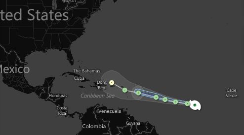
Image from: Hurricane Tracker by weatherchannel.com “Hurricane Maria” is predicted to pass to the North of the Dominican Republic HOWEVER, the Dominican Republic IS within the “cone of probability” so the possibility of a direct hit cannot yet be ruled out.
HOWEVER
IF Tropical Depression 14 sticks to her Northern track, then the Dominican Republic and Casa de Campo has nothing to worry about, but before you go back to your round of golf on the Teeth of the Dog, consider these facts:
On AVERAGE, a Tropical Cyclone’s actual path differs from it’s predicted path by 200 miles!
On AVERAGE, a Tropical Cyclone’s actual strength (ie. category) differs from it’s predicted strength by 2 categories!
What does this mean? – Essentially that right now, we do not know where Tropical Depression 14 will go or how big she will be…..we just have to wait!
We suggest that you follow the movements of Tropical Depression 14 closely so that you can be fully prepared, the below links are fantastic sources for keeping up-to-date:
This article was written by Rebecca Hughes, editor of Casa de Campo Living and Casa de Campo’s entertainment specialist!
Rebecca Hughes, Editorial and Events Marketing
rhughes@casadecampoliving.com
TEL: 809-523-2045 CEL: 809-949-8906
BBM: 230DA5D1
Altos de Chavón, Casa de Campo


