UPDATE, 2.30pm Tuesday 6th September The “Tropical Wave” now has a 90% chance of developing into a Tropical Cyclone…….see below for a full update
With Hurricane Katia whirring around above us in the Northern Atlantic ocean, causing impressive waves and a nasty storm surge on the Northern side of the Dominican Republic – it’s time to point our eyes to the East, where another storm is brewing……
It’s September, historically the most “active” month of the Atlantic Hurricane season in the Dominican Republic and if current weather predictions are anything to go by – it certainly looks like we’re in for a bit of a bumpy ride!
So what is going on?
As always with weather predictions – we don’t really know with any certainty what if anything is headed our way, however here is my ‘at a glance guide’ to what we do know:
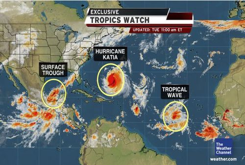
Weather Overview
Hurricane Katia, currently a major category 3 hurricane is located 650 miles North of Santo Domingo.
A “Tropical Wave” has formed in the Atlantic ocean – this “Tropical Wave” has a 90% 70% chance of organizing and becoming a Tropical Cyclone in the next 48 hours.
Hurricane Maria? Could this “Tropical Wave” be Hurricane Maria? Yes – that is possible, however:
This system has a 90% 70% chance of becoming a Tropical Cyclone within the next 48hours – which basically means she will become a Tropical Cyclone sometime soon
Don’t panic – “Tropical Cyclone” does NOT mean hurricane. The first level of a “Tropical Cyclone” is a Tropical Depression, then Tropical Storm and then Hurricane – so it is possible that this system will become nothing more than a Tropical Depression. [Click here to read more about Tropical Cyclones and their classifications]
Until this “Tropical Wave” actually develops it is rather difficult to predict anything about what ‘she’ will become or where ‘she’ will go
Headed this way?
YES! Predictions by weather.com have this “Tropical Wave” heading this was as a Tropical Depression, or possibly as Tropical Storm Maria. From the above diagram, it looks like we can expect a bit of a wet and windy weekend!
NO!! These forecast models taken from wunderground.com show the predicted track of this “Tropical Wave” headed to the North of the Dominican Republic.
CONCLUSION? Looks like we’re going to have to wait and see where she’s going!
UPDATE, 2.30pm Tuesday 6th September Since I published this article, less than an hour ago – I just went back to stormpulse.com (because I’m obsessed) and discovered:
“Tropical Wave” now has a 90% chance of developing into a “Tropical Cyclone” – very likely meaning a Tropical Depression, possibly a Tropical Storm and hopefully not a Hurricane
Another “potential disturbance” has just popped up close to the Leeward islands – although this has a low (10%) chance of developing , however early predictions suggest that it will move westward and bring us some heavy rain
We suggest that you follow the movements of this “Tropcial Wave” closely so that you can be fully prepared, the below links are fantastic sources for keeping up-to-date:
This article was written by Rebecca Hughes, editor of Casa de Campo Living and Casa de Campo’s entertainment specialist!
Rebecca Hughes, Editorial and Events Marketing
rhughes@casadecampoliving.com
TEL: 809-523-2045 CEL: 809-949-8906
BBM: 230DA5D1
Altos de Chavón, Casa de Campo


