

This post is also available in:
![]() Inglés
Inglés

UPDATE: Wednesday 3rd Nov. 2010, 12:00PM – Tropical Storm Tomas…
GOOD NEWS folks – although Tomas’ predicted path has not changed (he’s still set for Haiti), predictions now say that Tomas will NOT become a hurricane, he is currently a mere Tropical Depression and is set to develop into nothing more than a Tropical Storm over the next 24 hours! Now let’s just hope that all those nasty clouds disappear and leave Haiti alone!
Of course it’s not over yet….anything could still happen – please keep checking back to make sure your are up-to-date on the storms progress. For the LIVE picture, click here.

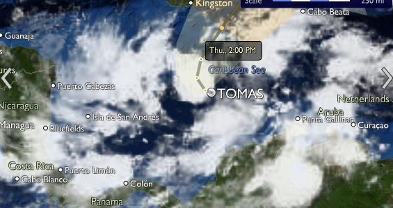
UPDATE: Wednesday 3rd Nov. 2010, 9:00AM – Tropical Depression?
Having yesterday ‘gone west’ our enemy Tomas, has now started to turn northwards (as was predicted) and so looks to be following the predicted path – heading across Haiti. Tomas is currently only a Tropical Depression with wind speeds of only 35kph and although we are all praying he will stay that way, predictions are that in less than 6 hours he will once more form into a Tropical Storm and within 48 hours become a category 1 hurricane, hitting Haiti by Friday.
The good news? Well for any optimists out there (like me) if you look at the below photograph of the clouds, you can see that ‘Tomas’ has no real organised formation, looks to be like a lot of clouds – of course I’m not a meteorologist, but surely there is a chance that the clouds might just all float away into nothing?!

Tomas who? The currently unorganised clouds predicted to once more become Tomas
(Photo from Weds, Nov 3rd, 9am)

UPDATE: Tuesday 2nd Nov. 2010, 7:00PM – A glimmer of hope for Haiti and the Dominican Republic!
Since this morning Tropical Storm Tomas has travelled further West than predicted, meaning that, although Tomas is still expected to gain strength tomorrow, possibly developing into a category 2 hurricane before it hits Haiti, it is now predicted that the core of the storm will pass 100 miles to the west of Port-au-Prince. Great news for Haiti and good news for the Dominican Republic, as far as us here in the DR (and our neighbours Haiti) are concerned the further west Tomas goes the better! GO WEST….
Of course, please remember that TOMAS has so far moved in a HIGHLY ERRATIC manner and so it is impossible to accuratly predict where he will go – keep checking back to make sure your are up-to-date on the storm’s progress. For the LIVE picture, click here.

UPDATE: Tuesday 2nd Nov. 2010, 10:00AM
Since yesterday morning Tropical Storm Tomas has travelled approximately 200 miles across the North of Venezuela and is currently to the North of the Venezuelan-Columbian border. Over the next 24-48 hours Tropical Storm Tomas is predicted to change path and curve back towards the Dominican Republic and Haiti and by is EXPECTED to gather momentum and become a category 1 hurricane with a projected path across Haiti and the Dominican Republic, Cuba and Jamaica. Please remember that storms and hurricanes are unpredictable – please keep checking back to make sure your are up-to-date on the storms progress. For the LIVE picture, click here.

Monday 1st Nov. 2010: Santo Domingo starts to feel the force of the storm
The below image was take on Monday in Santo Domingo; waves reportedly 7 foot high hitting the Santo Domingo coast – allegedly closing the Malecon
(Photo taken from the Facebook profile of Leonor Asilis.)

UPDATE: Monday 1st Nov.2010
Hurricane Tomas has currently been downgraded to Tropical Storm Tomas, seemingly good news. However since publishing this article yesterday, the storm/hurricane’s predicted path has changed, so that the DR now lies within Tomas’ potential path’ AND the hurricane/storm is predicted to gather momentum and become a category 2 hurricane before it hits land in Haiti.
To follow the storm click here.
Whilst their is no cause for alarm or panic for people living in the Dominican Republic, as hurricane Tomas is predicted to pass beneath the DR, we can be certain that the Dominican Republic will be effected in some way. It is important to make sure you keep yourself up to date on hurricane Tomas’ progress, so that if the worst happens you can be prepared.
Currently a category 1 hurricane, Tomas is predicted to lose momentum by tomorrow and be downgraded to a Tropical Storm, unfortunately, by Wednesday it is predicted to gather momentum again, turning into a category 1 hurricane and then category 2 by Friday, when if predictions are correct it should hit Haiti. However, as you will see from the photos Tomas’ path is somewhat unpredictable – our advice is to regularly check the weather updates over the next few days.
As you can see from the above photo the hurricane’s predicted path goes beneath the DR and then curves sharply towards Haiti, however, if you look at the photo below you can see that hurricane has a number of other predicted paths.

What does this mean for the us in the DR (Casa de Campo)? Rain and wind! Whatever happens, hurricane Tomas will bring lots of rain and wind – predicted to start tomorrow (monday) morning.
STAY UP TO DATE with our StormTracker, click here to see the storm’s live progress.